Articles
Locating a Photo of a Vehicle In 30 Seconds With GeoSpy
April 19, 2025

Vehicle theft remains a persistent and costly challenge for law enforcement and communities alike. Despite traditional methods like surveillance, eyewitness accounts, and GPS tracking, recovering stolen vehicles can be slow and often unsuccessful. Increasingly, investigators are turning to new technological solutions to tackle this issue.
At Graylark we have spent a lot of time thinking of how we can build AI systems to help speed up visual investigations. Our first system, GeoSpy, was a photo geolocation tool that enabled users to upload photos and get location estimations ranging from 1-25km in accuracy. This was a paradigm shift in the way investigators were able to locate images online. While the first version of GeoSpy was a step in the right direction there were challenges when it came to the final steps of locating images down to exact coordinates. Many folks came to us asking for the ability to locate a photo within a few feet rather than a few miles. To address that challenge we introduced a new AI model within GeoSpy called SuperBolt. This is a revolutionary AI system that allows for location tracking with accuracy as close as 1 meter.
This represents a significant step forward from slow and inaccurate manual location searching, enabling investigators to determine precise locations from images alone, even when visible landmarks are minimal or missing entirely.
Precise Matching vs. General Estimation
The main difference between these two different photo geolocation methods are based around accuracy and potential search area. Geoestimation is when you take the details from a photo like architecture, vegetation, and solid composition and estimate a corresponding lat lon. There are many different ways to do it but what is the most important is minimizing the average error your method of prediction encounters. In order to be useful, geoestimation systems need to be able to predict a city or country accurately. To do this a large set of global image data with geotags is required. Once you have this system, you basically have a model of what the world looks like visually and you can start inferring locations based on details from the photos. Typically these predictions are good as a starting or pivot point for investigations but do not immediately lead to actionable locations without further investigation. Geoestimation may still save hours or days of staring at images, but they still require analysts and investigators to do further research.
Geomatching requires a large amount of dense geotagged image data to act as a reference database. This data can be achieved through mapping services such as HiveMapper or Mapillary. This allows for extremely accurate location predictions, but limits the prediction area to the size and coverage area of the database. Typically these databases are the size of cities, counties, or states. A single city alone might require millions of images. You must also have a method of matching query photos to your reference database. We developed a method for collecting and processing millions of images extremely quickly turning potentially terabytes of image data into a few gigabytes. Some challenges we had to overcome included the ability to scale our reference databases to billions of images, being robust to repainted buildings, blurry images, and low light conditions. By using some of the latest advancements in AI architecture and training hardware, we were able to create an extremely accurate and fast method of locating a photo within a few feet.
The Power of Complementary Tools
The GeoSpy suite of ai tools work amazingly together, creating a powerful two-step approach to location identification. If you don't know the general location of a photo, you can first use GeoSpy’s estimation tool to get a general location prediction at the country, region, or city level. Then, once you know the approximate area, you can leverage our matching tool to pinpoint the exact address or get within meters of it. This complementary workflow dramatically increases efficiency and success rates for investigators dealing with vehicle theft or other location-critical cases.
Why GeoSpy Matters for Vehicle Recovery
GeoSpy addresses critical limitations of traditional investigative methods:
Rapid Location Identification: Quickly narrows down search areas, significantly increasing recovery chances.
Enhanced Scalability: Efficient handling of extensive image databases provides investigators the ability to search broadly yet precisely.
Dependability: Robust performance under varied environmental conditions ensures reliable leads even from low-quality or limited images.
Resource Efficiency: Saves significant time and resources by automating previously manual investigative processes.
Practical Applications in Investigations
Superbolt offers investigators powerful new tools for recovering stolen vehicles:
Quickly determining the location of vehicles from social media or online marketplace images.
Verifying authenticity and origin of suspect imagery.
Identifying key locations such as chop shops, staging areas, or hideouts.
Streamlining broader investigative tasks such as fraud detection and security analysis.
Real-World Example: Marketplace Listings
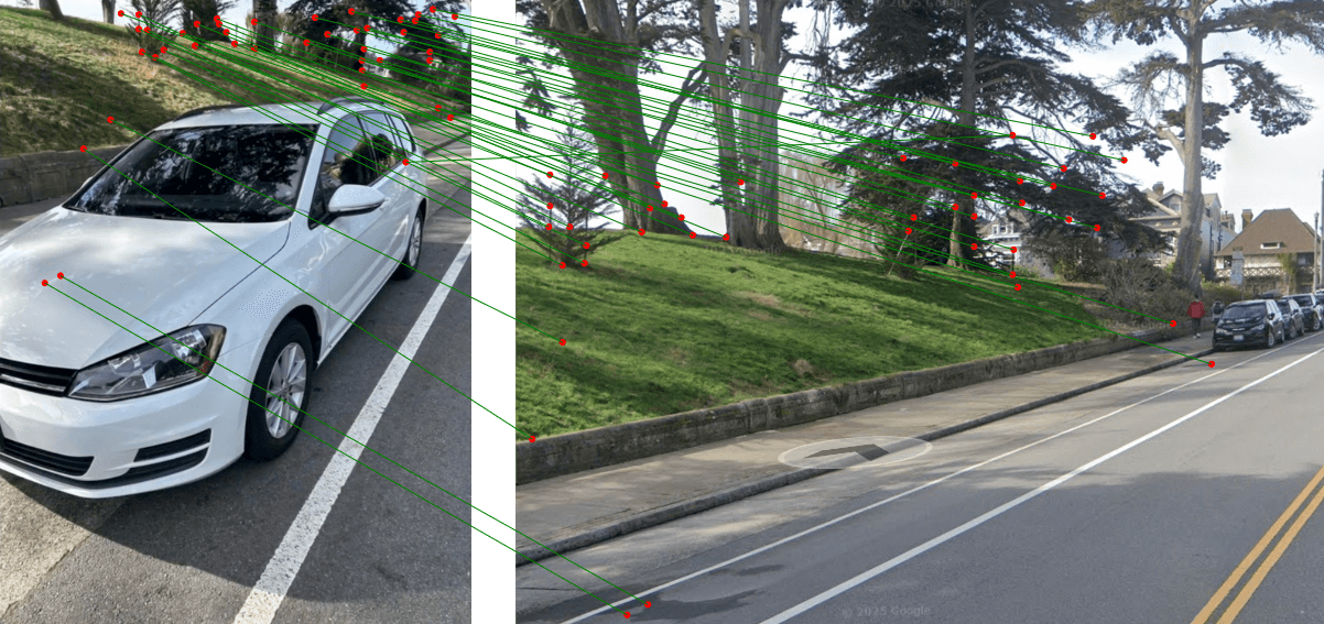
Here's a compelling example of GeoSpy in action: Thieves often post stolen vehicles for sale on platforms like Facebook Marketplace or Craigslist, inadvertently including visual clues in the background of their photos. When browsing Craigslist, I came across a regular car listing that showed a vehicle with buildings visible in the background. The listing claimed the vehicle was located in San Francisco.
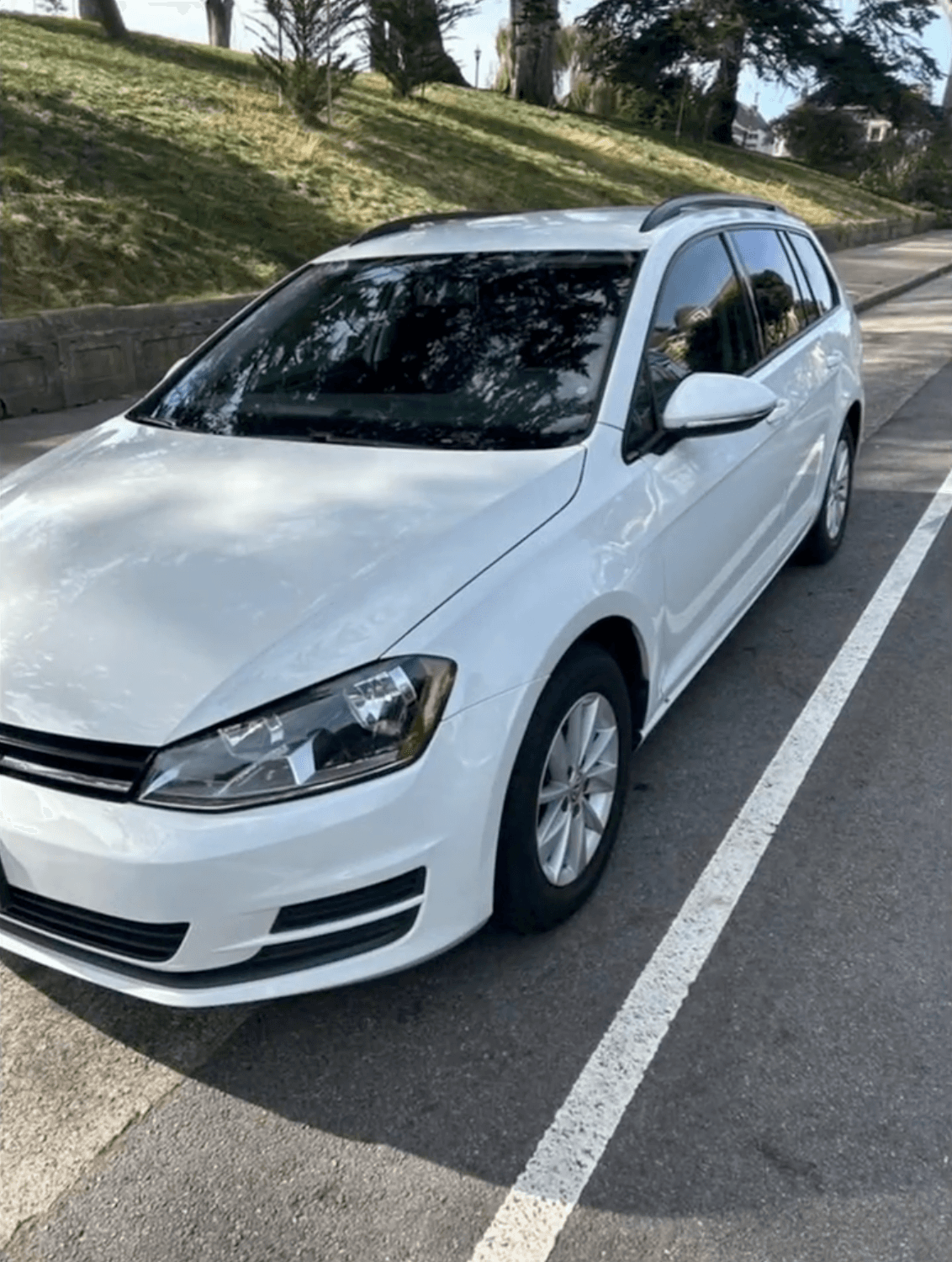
San Francisco happens to be a city in our image matching database and we are able to analyze the background elements visible in the listing photos. Superbolt returned precise latitude and longitude coordinates that, when entered into Google Maps, revealed an exact match to the buildings visible in the listing photos.
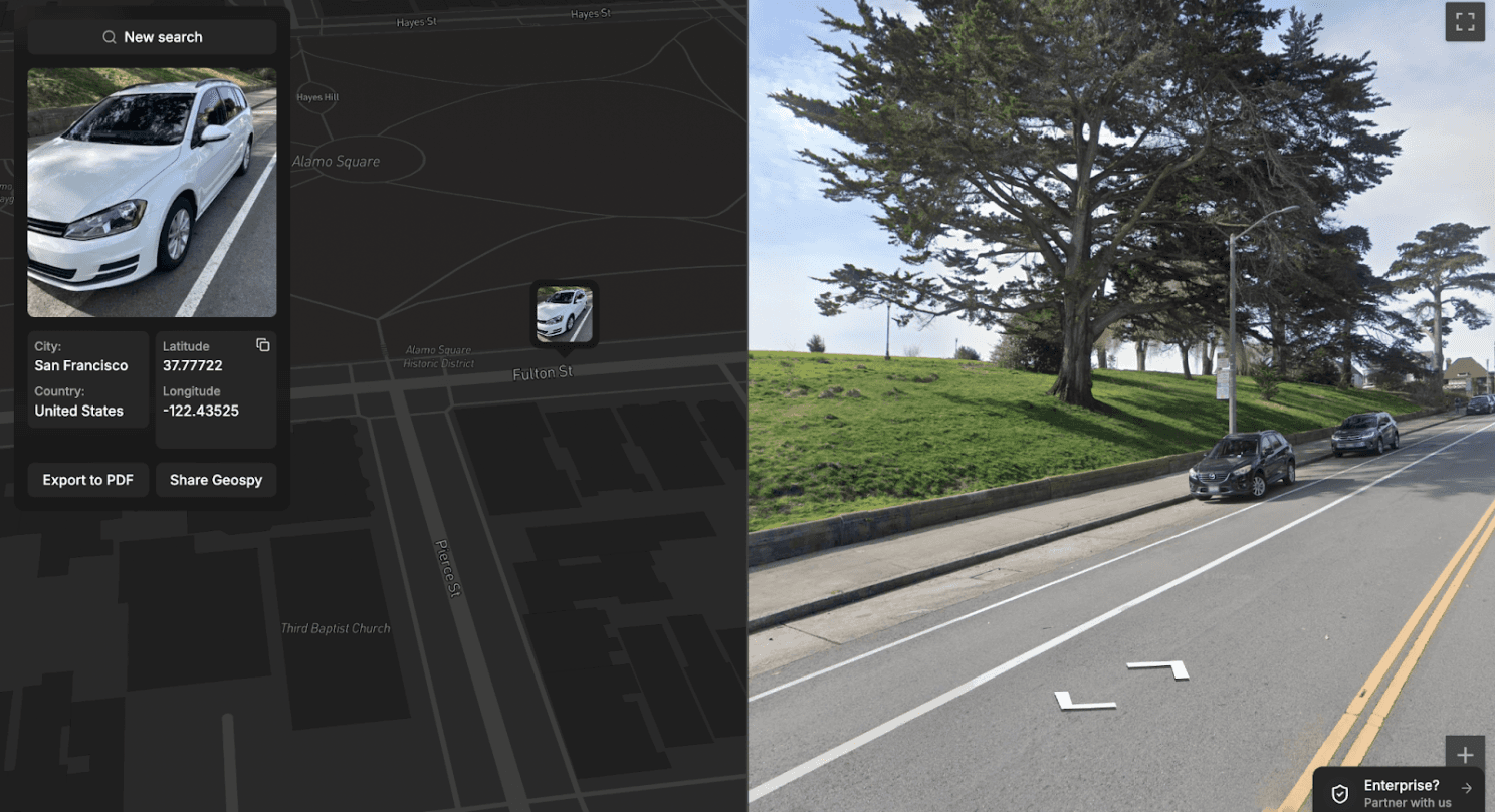
You can see how if this was a case of a stolen vehicle, law enforcement could quickly locate and recover the stolen vehicle before it could be sold to an unsuspecting buyer. Without Superbolt, identifying the precise location would have required extensive manual searching or might have been impossible altogether, highlighting how this technology dramatically accelerates the recovery process while requiring minimal investigative resources.
Shaping the Future of Investigative Work
Superbolt is not merely a technological enhancement—it's transforming the landscape of investigative work. By harnessing the power of AI-driven photo recognition, law enforcement agencies can achieve faster resolutions, greater efficiency, and better outcomes for vehicle theft cases.


